Case of 3D GPR application in highway asphalt pavement cracks detection test field
發布時間:2018-06-20瀏覽次數:4442來源:歐美大地
A project overview
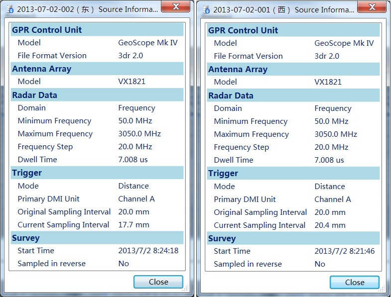
The purpose of the experiment: To carry out the cracks of asphalt pavement pavement substructure detection using 3D-Radar 3D gpr. Test location: The Ministry of Transportation Highway Test field. Test equipment: Ministry of Transportation Highway 3D radar, host: GeoScope IV, antenna array: VX1821 that is 1.8 meters long, 21 pairs of antenna, antenna channel spacing is 7.5cm, air coupled antenna, Trailer mounted.
Two, test road
The test section length of 26 meters, the two data collection section, East Road (far away from the warehouse side) have obvious cracks in 7-18 meters, 7-12 meters in longitudinal section has a 5 X 0.8 square meters area was sunken. West Road (near the warehouse side) on the surface is not damaged.
The principle of water area radar based on the strong test, using artificial watering, the water seeping into the roadbed, and on the road was not water collecting data.
Three, radar data acquisition settings
Set the frequency: 50 MHz - 3050 MHz frequency step is 20 MHz; the dwell time (each frequency transmitting time of 7.008 microseconds); longitudinal sampling distance is about 2cm;
Two acquisition settings as shown below:
Four, data analysis and data interpretation
Using 3D-Radar data analysis for data analysis software 3dr-Examiner V2.80.
One The eastern section of the data: Comparison of different channel profile: in the longitudinal section of 7-13 meters, from third to fourteenth channel profile typical figure 2. other channels typical longitudinal section diagram of figure 1. shows, third to fourteenth channels, according to the calculation of lateral spacing between channels is 7.5cm, abnormal transverse distance is 0.825 meters. The visual and road sinking zone agreement.
The dielectric constant is not the core calibration medium, the dielectric constant of 5 according to estimates. The test section shows the road asphalt layer is about 5cm thick, the water layer pavement distance is about 30cm.
Figure 3 shows the profile: 7-18 meters of reflection is more intense, more long 7-13 meters. This is full of water and cracks.
Figure 4 to figure 9 for the horizontal view of different depth. Reflect the water area change with depth, water depth in the area that can be roughly reached the water layer, and 13-18 meters long, with deeper water.
Five, conclusion
Through the comparison of the East, west section of radar data map, we can see that there are cracks, subsidence area waveform is not the same. Medium water, radar detection effect will be enhanced. After trying to carry out 3D-Radar data acquisition, 3D radar detection research on pavement cracks, it is a good method.
Six, GeoScope The 3D GPR is introduced
GeoScope 3D GPR system is introduced by American 3D-Radar Corporation, is a powerful and flexible underground NDT tools, the use of internal radar acquisition highway, airport runway, municipal road 3D exploration information in advance that separation, water, large area crack disease and preventive maintenance is becoming an important part of the construction of digital smart city. The 3D Radar is the world leader in leading the development of the industry.
The 3D radar system GeoScopeTM uses digital stepping frequency technology, for a variety of different applications, using different frequency range, through the acquisition of software parameter settings to control the entire spectrum, optimize the relationship between the detection depth and resolution of the radar system, target detection to obtain the best image quality; while GeoScope uses the electronic scanning antenna array technology that can make 3D exploration rapidly and accurately, realize the 3D detection real; GeoScope acquisition software can real-time display 3D image, is currently on the market only to realize 3D imaging radar system.
Application Area GeoScope has high flexibility, has extremely extensive application, such as:
Road detection
Bridge panel detection
Survey and mapping of underground pipelines
Airport Runway Detection
Inspection of Railway Subgrade
Archaeology
Mines and unexploded ordnance detection
The Advantages Of The System
The step of innovation into the host digital frequency radar technology
The application of antenna lead GPR antenna design wireless electronic scanning array technology
The real-time three-dimensional display of test data and analysis results
High resolution NDT equipment best road